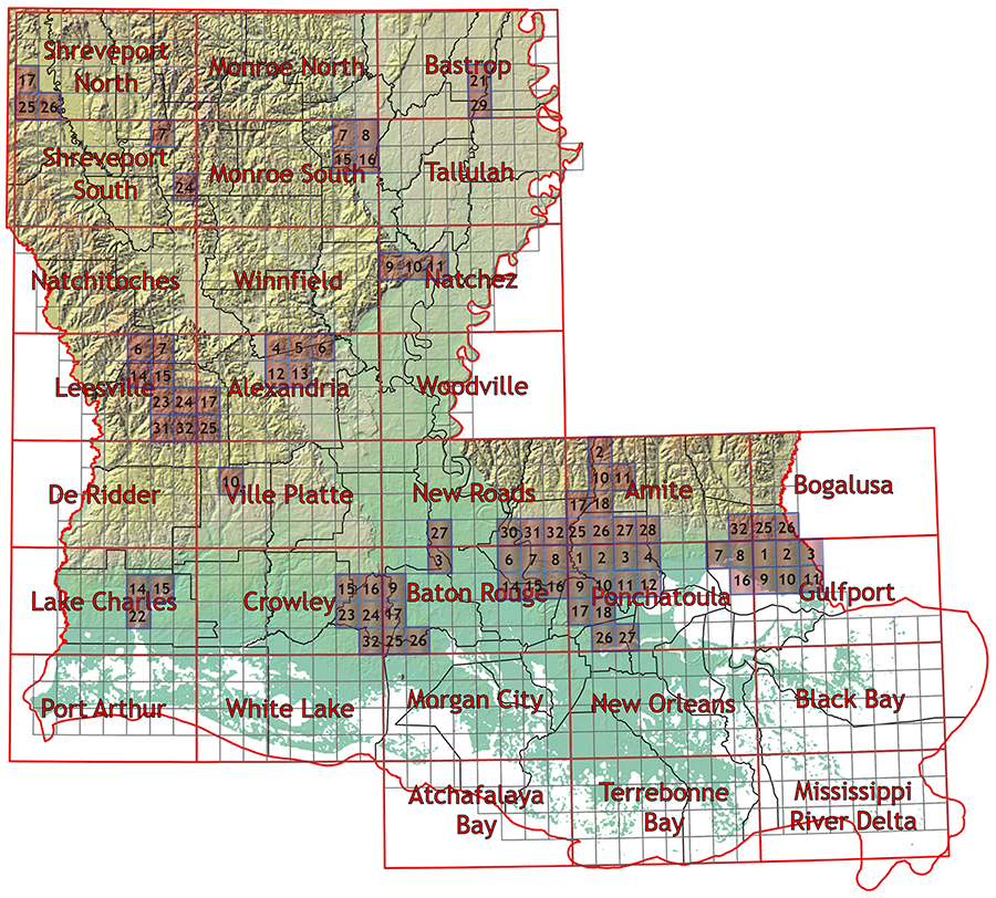
1:24,000 scale Surface Geology
While we strive to provide accessible content to all of our users, we are aware that some may experience barriers due a disability when utilizing our maps. As technology improves, we will continue to work towards creating more accessible alternatives in the future. If you are in need of assistance, please contact the Louisiana Geological Survey. email: lgs@lsu.edu phone: (225)578-5320
Descriptive pamphlets are available for recent maps. These are denoted with "Pam". Click on "Pam" to download the pdf document.
Disclaimer: "The views and conclusions contained in these documents/data are those of the authors and should not be interpreted as necessarily representing the official policies, either expressed or implied, of the U.S. Government or the state of Louisiana. These maps/data have been carefully prepared from the best existing sources available at the time of preparation. However, the Louisiana Geological Survey and Louisiana State University do not assume responsibility or liability for any reliance thereon. This information is provided with the understanding that it is not guaranteed to be correct or complete, and conclusions drawn from such data are the sole responsibility of the user. These regional geologic quadrangles are intended for use at the scale of 1:24,000. A detailed on-the-ground survey and analysis of a specific site may differ from these maps."
Ordering Information:
View Ordering and Shipping Charges
Please use the map below to determine the area in which you are interested. Then scroll to the map list to view available data/maps. A red box indicates map and/or data available.
Alexandria
4 Rock Hill (shapefiles)
5 Ball (shapefiles)
6 Green Gables (shapefiles)
12 Rapides (shapefiles)
13 Alexandria (shapefiles)
17 LaCamp (shapefile)
25 Fullerton Lake (shapefile)
Amite
10 Hatchersville (shapefiles)
11 Greensburg (shapefiles)
18 Pine Grove (shapefile) Pam
27 Holden (shapefile)
28 Albany (shapefile)
Atchafalaya Bay
Baton Rouge
3 Maringouin NW (shapefile)
6 Lobdell (shapefile)
7 Baton Rouge West (shapefile)
8 Baton Rouge East (shapefile)
9 Breaux Bridge (shapefile) Pam
14 Addis (shapefile)
15 Plaquemine (shapefile) Pam
16 Saint Gabriel (shapefile)
25 Youngsville (shapefile) Pam
26 New Iberia North (shapefiles)
Black Bay
Crowley
15 Mire (shapefile)
DeRidder
Gulfport
1 Saint Tammany (shapefile)
2 Hickory (shapefile)
3 Nicholson (shapefile) Pam
9 LaCombe (shapefile)
10 Slidell (shapefile)
11 Haaswood (shapefile)
Leesville
6 Peason (shapefiles)
7 Kisatchie (shapefiles)
14 Dowden Creek (shapefile)
15 Kurthwood (shapefile)
23 Slagle (shapefile)
24 Simpson South (shapefile)
31 Fort Polk (shapefile)
32 Birds Creek (shapefiles)
Mississippi River Delta
Monroe North
Monroe South
7 West Monroe South (shapefiles)
8 Monroe South (shapefiles)
15 Luna (shapefiles)
16 Bosco (shapefiles)
Morgan City
Natchitoches
New Orleans
New Roads
22 Port Hudson (shapefiles)
23 Zachary (shapefiles)
24 Fred (shapefiles)
27 Lottie (shapefiles)
30 Walls (shapefiles)
31 Scotlandville (shapefile)
32 Comite (shapefiles)
Pontchatoula
1 Denham Springs (shapefiles)
2 Walker (shapefiles) Pam
3 Frost (shapefile)
4 Springfield (shapefile)
7 Madisonville (shapefile) Pam
9 Prairieville (shapefile)
10 French Settlement (shapefiles) Pam
11 Whitehall (shapefiles)
12 Killian (shapefiles)
17 Gonzales (shapefiles)
18 Sorrento (shapefiles)
26 Convent (shapefiles)
26 Lutcher (shapefiles)
Port Arthur
Shreveport North
17 Mooringsport (shapefiles)
25 Blanchard (shapefiles)
26 North Highlands (shapefiles)
Tallulah
Terrebonne Bay
